There is, of course, a reason. If one is dealing with an author like J.R.R. Tolkien how took great pains to keep track of small details like how the moonphases change as time passes in 'The Lord of the Rings', one can, by carefully using the information from many small details in the text, reconstruct the map Tolkien used. Of course, this isn't actually necessary as he provided a map of Middle-Earth in the first place.
Clearly, MZB is not an author like this. Her concept of the geography of Darkover works in a completely different way. This is best illustrated by the two visits to the town of Hali by Romilly McAran in HM. While on the first visit, Hali is described as an unwalled city (HM:631), when Romilly comes back a bit more than a year later with the armies of Carolin Hastur, the walls of Hali are manned by soldiers and sentry birds (HM:754).
One could of course assume that Rakhal Hastur of Elhalyn fortified the town during that year. However, such a project would have taken enormous resources and is nevertheless never mentioned anywhere. Probably, the true explanation is different: The role of Hali, on Romilly's first visit, is to impress a mountain-bred girl with the lowland civilization. Hali is no mere frontier town which must be walled to be protected from bandits, Hali is a proud settlement and build to show the wealth of the inhabitants. On Romilly's second visit however, the role of Hali is completely changed. Now it is the last retreat of Rakhal and Lyondri Hastur and the place where Orain of Castamir is held - and to reflect this changed role, Hali acquires walls.
A similar example is the appearance of Caer Donn. When Romilly reaches Caer Donn in HM, Castle Aldaran is clearly seen above the town (HM:595). Yet, in SQ, a large part of the story takes place in Castle Aldaran, and Caer Donn isn't mentioned even once as long as the story takes place in Castle Aldaran, although there are passing references to it e.g. in SQ:166. Of course, SQ takes place before HM, for example in SQ the beginning of laran warfare is seen where the more devastating weapons like bonewater dust are not yet used, so it is possible that Caer Donn was a rather minor place at the time of SQ. Again, while this is possible, the growth of a mountain town isn't necessarily very fast. But seen from the role of Castle Aldaran, the appearance of Caer Donn makes perfect sense: In SQ, Castle Aldaran is a place remote from the political affairs of the lowlands, almost an exile for Allart Hastur of Elhalyn. Likewise, Renata Leynir is far from the influence of her family, and can so enter the love affair with Donal Delleray. So, the absence of Caer Donn helps to convey the sense of isolation in Castle Aldaran. On the other hand, in HM the role of Caer Donn is the staging point for Carolin Hastur's army - and for this purpose, a town is absolutely needed.
Thus, the idea of a place is far more prominent for MZB than any details associated with this place. She does have a mental map of Darkover, but not in the sense of an ordinary map. For example, the idea connected with Serrais is that the Ridenow clan represents former Dry Town bandits who overran the clan of Serrais and married into their women. Serrais is thus close to the Drylands. This sense of closeness is part of the mental map, not if Serrais is somewhere in the East or in the South, wherever it is, the direction to Serrais is also the direction to the Drylands.
Similarly, there is a crucial difference between the north-south axis and the east-west axis. For anyone living in the northern hemisphere (like MZB), north is usually associated with cold and a more rough country whereas the association of south is warmth and a pleasant country. Darkover is not an exception - in the north, we find the Hellers whereas the south has the Plain of Valeron. Thus, north and south are more or less directly linked with ideas - but east and west are not. Going east or west doesn't imply a clear mental change in the landscape. as going north or south does.
True to the concept of a mental map, information from text passages will be weighted. The idea of a place (such as the fact that Nevarsin is in the Hellers) is therefore more important than actual directions or distances given. For example, when a direction is given as north, I assume that this means any direction between northwest and northeast and not necessarily due north. Likewise, establishing actual distances out of descriptions of travel time is not straightforward and requires some care. The guiding principle is to end up with a map which incorporates all the important ideas about which places are close and which are remote, which places are in mountains, in hills or at the seashore, and not so much with a map which can accomodate every description of a direction found in the novels.
However, first of all, there is a caveat: While a journey might have taken 10 days, the length of the Darkover day is stated to be 28 hours in (SD:32,TH:695). The length of the year is said to be 389 days (WW:128), but this is not very consistently observed by MZB.
For example, Romilly MacAran leaves Nevarsin at Midwinter (HM:570ff), and after a 10 day journey through the Hellers arrives in Caer Donn - where she is noticing that spring is in the air and no more severe snowfall is likely to come (HM:604)! This points to a rather short winter. Similarly, after a few days in Caer Donn, she travels south to Hali where she arrives about 11 days later (HM:617,621). She and Jandria Hastur leave immediately for Serrais which they reach after another 7 days journey (HM:651). And 40 days after arriving in Serrais (i.e. 70-80 days after Midwinter), she remarks that Midsummer is approaching (HM:659)! Both the length of winter and the time between Midwinter and Midsummer point to a year with not much more than 180 days in HM.
This in itself is hardly a problem, but in SQ, Dorilys Aldaran is described as 11 summers old (SQ:123), but looking like a woman already. If the day on Darkover would have the length of a Terran day, even allowing for 28 hours instead if 24 hours, this would give Dorilys the biological age of 5-6 years. Given that Terran and Darkovan physiology is the same, Dorilys would hardly look anything like a woman! This on the other hand goes well with the 28 hour day and the 389 day year - the biological age of Dorilys would be almost 14 in this case.
Most likely the account in HM is a slip by MZB, or we must assume that at this time she assumed that the Darkovan day has a length of something like 48 Earth hours. If so, this would have some severe impact on travel distances. However, most accounts agree with the given numbers, e.g. the passage of time as described in FT is well in line as the story starts in early autumn (FT:175) and only more than 40 days later, winter is coming (FT:248). In TH:321 it is claimed that the Darkovan year is in fact longer than the Terran, but again there is evidence that MZB imagined a shorter day is shorter, as the typical women's cycle is 40 days on Darkover (TH:414) but the average cycle on earth is 28 days. All in all, MZB did not seem to be overly concerned with getting these time measures consistent.
It is difficult to estimate the vecocity of an aircar, but given that the one used by Allart Elhalyn and his father Stephan Elhalyn in SQ:69 doesn't have a closed cabin, it can't be much more than 120 km/h. Historic open glider planes have top speeds of 60 km/h, but an optimum glide path for 40 km/h. However, gliders rely on updrafts to regain height, so only about half of the time flying a glider is spent going into a specific direction, thus the linear distance covered by a glider may be more something like 20 km/h.
Mongol riders under Ghengis Khan have been known to have covered in excess of 200 km per day in open terrain. However, this includes spare mounts for each rider. Modern distance riding competitions extend up to 160 km per day, so this is the distance which can be covered with a single horse, pushing the horse to its limit. Needless to say, horses can't keep up this speed for several days. Modern leisure trail riders cover about 35 km per day, but when asked how much they could do if they wanted to cover distance without leisure breaks, about 70 km per day in open terrain are considered a reasonable number. chervines are described to be slower than horses but better suited for mountaineous terrain, thus they can probably cover something like 50 km per day in open terrain, but don't get slowed down when climbing as much as horses.
From own experience, I know that 50 km can be covered by a trained hiker when necessary and with light baggage. However, 30 km per day can be kept up over several days even with a 25 kg backpack in hilly terrain.
Going up steep hills or mountains usually slows down significantly up to almost a third of the travel speed one can reach in level terrain. However, unless the trail is very steep, going down is as fast as going level. Since, when crossing mountains, one goes on average as far up as one goes down, the average speed is reduced to 45 km per day for a horse or chervine and to 20 km per day for a walker. However the fact that one cannot travel in a straight line in mountains even when there is a road is probably as significant as the elevation change. So to cover a linear distance of 10 km might easily involve an actual distance of 20 km on a mountain or hill road, reducing the effective travel speed to 20 km for a rider or 10 km for a walker.
Travel time also depends significantly on weather conditions. This can be seen from the fact that in early autumn, four days are considered sufficient to get invitations to the double wedding of Callista Lanart-Alton to Andrew Carr and of Ellemir Lanart-Alton to Damon Ridenow from Armida to Thendara and Serrais and guests to come (FT:208), yet a few tendays later during winter with heavy snowfall, 10 days time are planned for a trip to Serrais and back (FT:277). Travel time also depends on experience. In WD:573 we learn that Dan Barron with his party takes as much as 5 days to reach Armida from Thendara - but then again, he has never been on a horse in [his] life (WD:549), so it is grossly unrealistic to expect him to manage a full 70 kilometers a day as an experienced rider would. A nice comment on the different travel speeds of a single rider and a large party is made in SC:122 where Magda studies the distances to the next travel shelters.
Thus, 10 days ravelling by Romilly McAran from Nevarsin to Caer Donn through the far Hellers in winter would probably correspond to a linear distance of about 180 km, whereas 7 days of travelling through the Kilghard Hills together with Jandria Hastur, involving many detours, might amount to 140 km. On the other hand, the ride by Bard Di Asturien to Neskaya, done straight and without much consideration for the horse, might have been 160 km. The glider flight by Donal Delleray, Allart Hastur, Renata Leynir and Dorilys Aldaran described in SQ from Castle Aldaran to Tramontana tower could easily be done in a morning, thus hinting at a distance of 40-50 km. The escort, travelling by horse, calculated 2-3 days for the same distance, which is actually very consistent.
The lowlands are divided by the Kilghard Hills which are its most distinctive feature. These merge with the foothills of the Hellers, Romily McAran was born in the Kilghard Hills, but north of the Kadarin (HM:550), but stretch southward. Before crossing the Kadarin on the way to Castle Aldaran in the Hellers, Allart Elhalyn, Renata Leynir and Donal Dellerey see the Kilghard Hills away south (SQ:171). It is clear from the fact that Romilly McAran and Jandria Hastur cross the southern Kilghard Hills (HM:645f) that there is relatively level country east and west of the Kilghard Hills. The Kilghard Hills also do not stretch all the way southward towards the Sea of Dalereuth - Bard Di Asturien, on riding southward, leaves the hills behind him (TTC:206) and reaches the Plains of Valeron (TTC:213). Thus, there is also level country south of the Kilghard Hills.
The Kilghard Hills drop towards the Kadarin (SQ:171), this implies that the Kadarin drains the precipitation of the Hellers and the northern Kilghard Hills, but a different river must drain the southern Kilghard hills. It can be inferred by a somewhat longer chain of reasoning given below that this is the Valeron (TTC:201) which again flows for a time along the east-west axis through the Kilghard hills. Since the Plains of Valeron are found in the south (TTC:354) and likewise the Sea of Dalereuth, it would seem that the Valeron turns southward at some point after leaving the Kilghard Hills.
The Kadarin likewise at some point turns - Carthon is said to lie in the bend of the Kadarin (WD:623). Given that an account in WW:334 places the castle of the Lord of Carthon on the isle of Mormallor in the Bay of Dreams, the Kadarin probably turns southward at Carthon and reaches the Bay of Dreams. This would make the Kadarin also the dividing line between the Seven Domains and the Drylands which start beyond Carthon and agrees with the account of the journey of Rohana Ardais that a river needs to be crossed to get back to the Domains. The extent and borders of the Drylands are not described anywhere, but the fact that a journey from Carthon to Shainsa done in haste takes more than five days through level terrain makes them a region of considerable size.
On the other side of the Kilghards, the valley of Thendara and the Venza Hills (sometimes also called Venza Mountains) are found (SC:134). The Venza Hills directly border Thendara (TH:505). The fact that Elhalyn lands are in the western hills (seen from Thendara) (TH:386) and that lake Hali is an hour ride north of Thendara in the hills (FT:492) and that Thendara can be reached in a bit more than a day from Armida by a single man with a fast horse (FT:483) (which nevertheless requires the whole range of the central Kilghards to be crossed) would indicate that the Thendara valley is in fact a valley stretching from the Kilghards to the Venza Hills.
Beyond the Venza Hills are the Plains of Arilinn. Jeff Kerwin, on his first trip from Arilinn to Thendara flies over mountains (BS:301) and the mountain range looming over Thendara can just barely seen from Arilinn tower (BS:315). This suggests that the Plains of Arilinn are just a continuation of the Plains of Valeron. Since Romilly McAran crosses the Plains of Valeron going from the Hellers to Hali (HM:621) (which lies an hour ride north of Thendara (FT:492)), and since the Plains of Valeron are also known to lie far south (FT:175), and since the Valeron is not described to be close to Thendara and can hardly cross the Venza Hills, the solution is that the Valeron turns southward only after passing the Venza Hills where the area becomes known as the Plains of Arilinn, to merge with the Sea of Dalereuth further down where the area is again known as Plains of Valeron.
North of the Lowlands are the Hellers, the main Highland region of inhabited Darkover. The Hellers seem to be huge mountain ranges stretching roughly in east-west direction, but their valley systems are inhabited. However, the Hellers themselves are only the foothills of an even larger mountain range, the Wall Around the World (CS:781f,CS:1060). From the Hellers northward to this larger range is only wasteland (CS:773). There is not much told of the terrain beyond the Wall Around the World, but Terran satellite images reveal that beyond are only icy, barren wastes (CS:781f), so the known landmass of Darkover is also the only habitable landmass.
There is the expression From the Wall Around the World to the Bay of Storms (SE:638) which presumably means all of the known Darkover landmass. As the Wall Around the World is the northermost boundary, not of the really habitable region but of all known Darkover, so must the Bay of Storms be the southernmost known landmark beyond the Sea of Dalereuth (which is the southernmost inhabited point) - after all, Bay of Storms does not exactly sound inviting. The last known features of the southern coast are the Bay of Dreams and the island of Mormallor (WW:334).
Two more mountain ranges, the Hyades and the Lorillard Ranges, are mentioned in WD:582, however they are not placed. The Hyades can be tentatively placed by the thoughts of Brynat Scarface in (WD:534) that news of his conquest of Castle Storn will spread through the Hellers and Hyades - but he doesn't mention any other mountain range. This would indicate that the Hyades are, as the Hellers, a foothill range of the Wall Around the World and continue the range of the Hellers further to the east. This agrees with the account given in WW:165 which states that the Kilghard Hills are east of the Trade City (Thendara) and the Hyades and Hellers beyond them.
The name 'Wall Around the World' is revealing in itself. If the mountain range would only be in the north, a name like 'Wall at the End of the World' would be more fitting. As it is, the name suggests that the shape of the mountain range is rather that of a horseshoe, bounding the known lands of Darkover not only north, but east and west as well. The southern boundary is then given by the coast. This would also answer the question what is beyond the Drylands or beyond the Plains of Arilinn. The Lorillard Ranges can then be taken to be the foothills of the Wall Around the World in the region beyond the Plains of Arilinn (although strictly there is no evidence that this is so).
The elevations imply that the mountain ranges cover a huge territory. The base of a terrestrial mountain range is easily eight times the height, for example the rise from the Indus valley to the Nanga Parbat summit of 7000 m in just 27 km is exceptionally steep. Even considering the lower gravity on Darkover which allows for steeper mountain faces, the crossing of Scaravel in north-south directions from valley to valley would involve a distance of maybe 70 km, clearly in line with the description in CS. This may also be the explanation that only one major pass needs to be crossed to reach Nevarsin from the lowlands (CS:1046).
The Scaravel massive would have a substantially greater extension in east-west direction. Here may be the explanation that two different heights are given for the Scaravel pass - 4000 m (CS:851) and 7000 m (CS:935). Assuming this is not a simple slip of MZB, the name 'Scaravel' would refer to the mountain range, and any pass crossing this range would be named Scaravel pass. Then, the 4000 m elevation refer to the crossing to Sain Scarp and Ardais described in SC whereas the 7000 m elevation refer to a different crossing point of the range on the road to Nevarsin as described in CS.
The second major range of the Hellers is the range of Nevarsin peak, with Nevarsin pass leading northward at an elevation of 16.000 ft (CS:977, about 5000 m) merging with the Plateau of Leng to the west (ibid). After this range, the Wall Around the World is reached, thus the main bulk of the Hellers would involve two main ranges with a north-south extension of about 150-200 km, much more (in fact an unknown distance) in east-west. The Andalune pass mentioned in TH:311 is probably not part of the main ridges, as Scaravel is crossed later in the journey.
The third major range must then be the region around High Kimbi which is close to Aldaran (WD:561) and must be crossed to get south from there (WD:623). High Kimbi itself must be quite a remarkable peak, as it is noted also elsewhere (CS:815,HM:550).
The main ranges are described as far impassable peaks, where no human thing dwelled, but only trailmen and the half-legendary chieri of the far Hellers, in their fastness surrounded by eternal snow (SQ:96) or an enormous mountain range which lay, seemingly endless and to the very edge of their sight, wrapped in eternal snow, enormous and jagged and covered with glazial ridges and peaks below which pale clouds drifted (DL:44).
However, away from the main ridges and massives and a bit down in the valleys, the terrain is wood-covered. Glider-flying in the vicinity of Aldaran, Donal Dellerey and Allart Elhalyn see a quiet mountainous countryside (...), slope after slope of hills covered with dark forest (SQ:201).
The foothills of the Hellers are a relatively low-lying part of the Kilghards. Romily McAran sees the distant line of the Kilghard Hills from the window of Falconsward (HM:415) which in turn is at the river Kadarin, in order for this to possible, the central Kilghards must be substantially higher than the foothill region. However, the terrain appears to be very rugged, it is described as deep ravines filled to the brim with forest (HM:398) and bleak and bare with great rock cliffs (HM:645) or, seen with the eyes of Andrew Carr who has to cross this region to get to Armida from the crash site of the mapping plane as seemingly endless leagues of chasms and foothills and crags (SS:21).
The view from the central high sierras is described by Dan Barron: Cool purple, deep violet, pale greyed blue, they lay there fold on fold and height behind height, each successive fold rising higher and farther away, until they vanished in cloudy distances that might have been thunderheads - or further ranges. (WD:596). The central sierras are quite high - Ravensmark pass is 11.040 feet high (about 3400 m) (CS:866), which would place the mountain peaks well above 4500 m. In fact, the peak described in DL:43 (which for reasons to be given below must be located in the Kilghard Hills) is 18.000 feet (about 5500 m) - this appears to be the highest elevation. Still, it is clear that the Kilghards are considered foothills when compared with the Hellers - Scaravel Pass is considerably higher than the highest elevation in the Kilghard Hills. The terrain in the central Kilghards is described as steep trails (...) valleys below, with patches of snow clinging below the trees (...) rocky slopes (FT:467)
The southern Kilghards are less rugged, here one finds hills, high and steep and with great deserted tracts of wild country set with virgin forest and sometimes overgrown with thick brush tangles (HM:645), i.e. chiefly woodlands.
Romilly McAran describes the northern Plains of Valeron asgreen rolling hills (...) green and fertile, with crops blooming in the fields and trees without even snow-pods for their night-blossoms. (HM:621). The region around Arilinn further south is described by Jeff Kerwin as Outside the gates of Arilinn, the plains stretch[ed] wide, with clumps of bushes here and there, a few tracks and an old cartroad (BS:358)
In TTC, on discussing the strategical situation, it is established that Serrais is east of Asturias, Aldaran and Scathfell are north, the Hastur lands west and the Plains of Valeron south (TTC:354). Bard di Asturien is known as the Kilghard Wolf, and various other text passages confirm that the kingdom of Asturias is somewhere in the Kilghards. Thus, the text passage places Serraus east of the Kilghard Hills whereas the Hastur lands (presumably including Hali, Carcosa and Thendara) are west.
The situation is rather different in HM. Here, the army of Carolin Hastur gathers at Serrais, and on marching towards Hali, takes a road east towards the plains of Valeron (HM:687), and indeed finds the army of Rakhal Hastur later to the east of their own position (HM:715). However, it is flatly impossible if Serrais is east of the Kilghard hills and at the edge of the Drylands to take a road eastwards and reach Hali. Thus, the two descriptions cannot be reconciled.
However, it turns out that most stories is self-consistent in the sense that major contradictions in geography occur when comparing different stories, but not within a story (we deal with exceptions and other oddities below). But moreover, it seems that the geography is rather consistent also between stories when in some of them east and west are switched. For example, it is possible to draw a map of the travels of Romilly McAran in HM which fits nicely into the picture of the strategic situation of Asturias in TTC when one assumes that Carolin Hastur's army travels westward instead of eastward.
Thus, it is first of all important to establish the location of Serrais in the various stories in order to make use of the other geographical references. It can be seen that Serrais lies in the east in SS from the fact that Damon Ridenow, coming from Serrais (SS:51) and travelling to Armida in the Kilghard Hills, rides westward towards mountains (the Kilghards obviously) (SS:26). Likewise, in SC we learn that the Dry Towns are east of Carthon (SC:20), and since Serrais is at the edge of the Drylands, this and the fact that on returning from Shainsa in the Drylands, Rohana Ardais observes a sunset towards Carthon, i.e. is travelling westward to the Seven Domains (SC:68). WD places Carthon (and consequently the Drylands) east of Armida (WD:577). This establishes Serrais in the east in WD, SS and SC, as well as in TTC, see above.
In contrast, in SQ we find the description that Storn holds lands west of Caer Donn, close to Serrais across the Hills (SQ:158). The hills are obviously the Kilghards which separate lake Hali and Serrais, so this passage (and the fact that all attacks from the Ridenow clan seem to come from the west) establish tentatively that SQ is written with the idea of Serrais being in the west. Likewise, at least part of the descriptions in TH would place Serrais west, see below. Thus, at least in SQ and HM, the western direction leads towards Serrais.
In the following, we will simply decide to place Serrais in the east and mirror all descriptions in stories in which it is in the west to extract a consistent map. This is an arbitrary decision and could well be made the other way round, but it is in line with the idea of a mental map outlined above. In all descriptions which are cited, the original direction will appear in brackets as to avoid confusion. Thus, 'west [east]' means that the original has 'east', but adopting the convention that Serrais is east, this has been altered to 'west' for the purpose of mapping.
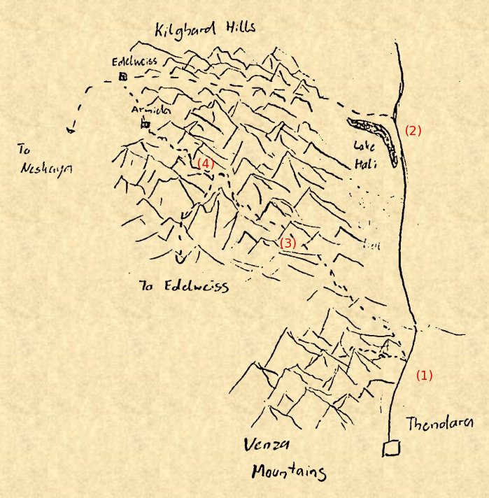
The map shows the great Northern Road leading from Thendara untimately to Caer Donn in the Hellers. Alessandro Li as well as Jaelle n'ha Melora and Magda Lorne face the choice which road to take to Armida. (1) is the first branching reached by Magda Lorne. From here, a small trail leads directly westward into the Venza Mountains via Dammerung pass, and it is clear that this is not the way to Armida. The main choices at this point are a small road through the Kilghard Hills directly to Armida, or continuing northward for a while until an intersection at lake Hali (2) and then turning westward on a main road to Neskaya through the Kilghards till Edelweiss, and from there south-east to Armida (note that this account places Serrais in the West) (TH:703,705,f). While this is the fastest road, both Jaelle and Magda suspect that Alessandro Li has taken the small direct road as it looks like a shortcut on the map (but, not apparent from the map, is much more difficult to travel).
(3) indicates the point at which Magda Lorne reaches the first pass on the side road at nighttime. From here, mountains are visible in the east (TH:709). It is quite clear from the map that this account is at odds with the descriptions given earlier which place both the Venza mountains and the Kilghard Hills into the west. At night in stormy weather, the visibility can't be too good, and ascending to the first pass Magda should in fact see mountains to the west but not to the east.
Finally, (4) denotes the branching point seen by Jaelle n'ha Melora. Here, a road leads southward into the mountains, eventually ending up at Edelweiss, though this is not the direct road (TH:717). It can be seen easily that this is a very strange description of the road - the fastest way to Edelweiss is to proceed to Armida and onward, and a southward road turns in fact away from Edelweiss - no one would possibly use it to get there, as it requires additional mountain climbing.
There is no real way to resolve these contradictions. The main idea which is important for the story is that there is a triangle of roads, one of which appears to be the faster way on a map, but is not so in reality. This triangle can be placed eastward without spoiling the story. The Venza Mountains would then remain in the west and, together with the Kilghard foothills, form the borders of Thendara valley, and Magda would be placed on the pass just right to see the central Kilghard high sierras. It is somewhat arbitrary where one would like to place Edelweiss, since there is another reference placing it north of Armida (FT:465) it seems easier to dismiss the idea that the southward road at (4) leads to Edelweiss.
The novel describes a westward crossing of woodland from Castle des Trailles north of Armida through woodlands and eventually a high mountain pass (SD:139,156,158ff) towards Hastur lands in the west. This can in fact be reconciled roughly with a journey through the northern Kilghard Hills leading out of the Hellers, and this is in fact how the journey is described later by MZB (WD:577). However, it is clear that other geographical details given correspond to an early concept of Darkover and must be dismissed for mapping purposes.
In a similar line, we may perhaps dismiss the fact that Edelweiss and Syrtis seem to be very close (HH:237) - in other sources, one would need to cross the Kilghards going from Syrtis to Edelweiss, which can be done in a day, but is clearly not around the corner. Thus, 'Heritage of Hastur' is in general not a reliable source to estimate distances, alhough some distances, e.g.. the 11 days from Edelweiss into the mountains to Aldaran (HH:301) or the 7 days from Aldaran to the lands of Armida (HH:362) seem realistic enough.
However, this is not compatible at all with later accounts. In FT:355 the distance from Armida to Arilinn is given as 10 days ride. Given that Armida to Thendara is a bit more than a day for an experienced light rider (FT:483) but 4-5 times that for a larger party, it is not unreasonable to calculate 3 days for the distance if horses should last longer. That would make Thendara to Arilinn of 7 days or less. To cover 1000 miles in 7 days on horseback is completely impossible - having spare mounts and driving the horses to exhaustion might just possibly give 1400 km, but a realistic distance is less than 450 km.
But we also have the account in BS:315 which states that the Venza Hills above Thendara are actually visible from Arilinn Tower. Even on a clear day, the visibility in clear air is seldom more than 250 km, so this may be the linear distance from Arilinn to Thendara. Since a rider would have to go around the Venza Hills, this agrees well with the 10 day ride quoted above. Thus, the 1000 miles distance must be dismissed as an early concept which was abandoned later.
The location of the Ridenow Domain at the edge of the Drylands is confirmed in several other places (SE:509,HM:659) and this is never contradicted anywhere. Likewise, the fact that both Ardais and Aldaran are in the Hellers is also confirmed in various places (SQ:171,FT:175,SE:415) and not contradicted. SC:42 places castle Ardais at the border of the Hellers, but in fact as the continuation of the story shows, it must be quite a bit further in - Scaravel pass has to be crossed in order to get to Ardais. That the Alton Domain is in the Kilghards is obvious throughout SS and FT, but as SQ:171 shows, it has been there even during the Age of Chaos. The Aillard Domain can also be established without contradiction at the seacost at Temora and Valeron.
The location of the Domains of Hastur and Elhalyn is a bit more troublesome. TH:386 places the Hastur lands east (of Thendara), thus also into the Kilghard Hills, but in FT:175 we learn that both Hastur and Ardais are north in the Hellers. This contradicts the above statement that the Hastur Domain is in the Kilghard Hills. Two more accounts can be used to place the Hastur Domain. In TTC:341 we learn that the Hastur lands are wst of Asturias. This would place them west of the Kilghard Hills, as Asturias is located there. This is confirmed in TTC:354. Finally, Larry and Kennard cross the Kilghard Hills in SD to reach the Hastur lands to the west (SD:135).
The location of the Elhalyn Domain is hardly ever mentioned. In TH:386 it is located in the western hills (seen from Thendara) - this would imply the Venza Hills. Clearly it must also include Lake Hali.
The following solution seems best to account for all information: The Domain of Hastur must be west of the Kilghard Hills, including some of the foothills. Its northern border are the foothills of the Hellers, and some of the mountain ranges may even be part of the Domain. Thus, it would mainly involve the upper Plains of the Valeron. The Domain of Elhalyn on the other side would involve Lake Hali, the Venza Hills and the continuation of the plains, most importantly the Plains of Arilinn. The southern Plains of Valeron are then the loaction of the Aillard Domain.
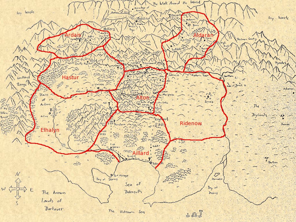
The kingdom of Asturias as it existed in the age of the Hundred Kingdoms must have been in the southern Kilghard Hills, south of the central high Sierras. Returning from a war in the Hellers, Bard di Asturien rides through the Kilghard Hills to reach Asturias (TTC:289). Likewise, riding southward, he leaves the hills behind and eventually reaches the Plains of Valeron at the southern border of Asturias (TTC:213). It is likewise clear that Asturias is south of the Valeron from the fact that the army of Asturias plans to take the bridges across the Valeron in the campain against Hammerfell in the north, so the influence of Asturias does not extend all the way through the Kilghards. Somewhere between Asturias and Hammerfell is the location of the market town Tarquil (TTC:200). North-east of Asturias is the shire of Marenji which is supposed to act as a buffer state to Serrais in the east (TTC:323) but nevertheless Bard crosses southward from Marenji into Asturias (TTC:333). Marenji is the location of the Isle of Silence in the Lake of Silence, the sacred place of the priestesses of Avarra (TTC:323).
Neskaya tower is located on the south-eastern border of the Kilghard Hills. The location is described as north of Mirin lake, at the edge of the Kilghard Hills (HM:690) and Neskaya is called a 'foothill city' (HM:445). Mirin Lake can possibly be identified with Mirion Lake mentioned in BS:450. In Bard di Asturien's time, Neskaya is in Ridenow hands, although outside of the lands of Serrais proper (TTC:343) which establishes its location to the east, and it can be reached in one day by a hard ride from Asturias (TTC:449). Neskaya must be south of Asturias, as the road from Neskaya to Asturias turns northward eventually (TTC:479). All of this agrees well with the fact that Neskaya is the tower which seems to be easiest to reach from Armida in winter (FT:306)- the eastern location makes perfect sense, as a rider from Armida would have to go southward in the plains only instead of crossing the Kilghards in heavy snow.
The region around Lake Mariposa is also known as Lake Country (HH:161,BS:352,SC:83). We must assume that there are many lakes in the foothills (after all, there is no major river system draining the Eastern Kilghards), but we only know a few, among them Lake Mariposa (BS:196), Lake Mirin (HM:690) or Mirion (BS:450) or Mirien, seat of the di Asturien family (SE:634), and Lake Miridon (SQ:172) (it is up to anyone's guess if all these are the same lake or different lakes). Leynir, the estate of Renata Leynir's family, is loacted between Lake Miridon and Lake Mariposa (SQ:172). The Lake of Silence (TTC:323) is also roughly in this area.
Hammerfell can be found in the northern Kilghards, in the high Sierras. This is evident from the fact that the party of Magda Lorne in CS discusses a detour via Hammerfell to Barrensclae (CS:866) in order to avoid crossing Ravensmark pass while still being south of the Kadarin (CS:897). Likewise, Hammerfell must be north of the Valeron in the Kilghards, as the strategy discussion between king Ardrin and Bard di Asturien involves going northward and holding the bridges over the Valeron to guard against Hammerfell (TTC:201).
Falconsward, the home of Romilly McAran, is at the northern bank of the Kadarin in the foothill region of the Hellers (HM:394,550).
We have a few clues as to establishing the relative location. We know that the Storns hold land east [west] of Caer Donn, close to Serrais (SQ:158) and that Storn is near to Aldaran (HH:114). This places the region around Caer Donn and Aldaran in the Eastern Hellers north of Serrais and the Drylands. There is a road from Caer Donn to Nevarsin (HM:590) and indeed this is later travelled by Romilly McAran in HM and does not lead via Ardais. Likewise, north of Nevarsin Pass, there is a road leading westward via the Plateau of Leng (which is impassible at the time it is reached) (CS:977) and a different road leading to Caer Donn (CS:990). We do not know where the road over the Plateau of Leng leads, but it is reasonable to assume that it leads opposite to the road to Caer Donn. The accumulated evidence suggests that Nevarsin is west of Aldaran, roughly north of the Kilghard Hills. This implies that the westward road originally led to Ardais, which must then be the most westward of the mountain regions. Note also that it is often mentioned that the Aldaran Domain is not part of the Comyn Council because it is so remote. In the geography we have outlined here, the argument does not apply to Ardais, which is just north of Thendara and thus while a mountain domain, still relatively close. But it does apply to Aldaran which is about as far from Thendara as one can place it on the map.
Close to Ardais is the stronghold of Sain Scarp (SC:114) which is, as Ardais, reached via the Scaravel Pass (SC:175). In the age of the Hundred Kingdoms, Sain Scarp was part of the Kingdom of Scaravel (TTC:285) and a place Alardyn which is presumably nearby is mentioned (TTC:285).
The monastery of St. Valentine of the Snows lies just above the city of Nevarsin. (HM:534). Four days north of Nevarsin, beyond Nevarsin pass and in the icy barren lands between the Hellers and the Wall Around the World is the Hermitage of Avarra (CS:990,1003). Even further north, in an undisclosed location possibly beyond the Wall Around the World is the secret city of the Sisterhood of Avarra.
Several estates are mentioned throughout SQ in connection with Aldaran - there is High Crags, Scathfell and Storn. Interesting enough, most of these must be to the west of Aldaran, as they are also the list of guests for the McAran Midsummer Festival at Falconsward (HM:448). In fact, in HM:550 Falconsward is said to lie in the 'country around Storn' - but then, the location of Storn lands may have changed repeatedly. WD:534 states that Castle Storn has been owned by Aldaran, Aillard, Darriel and Storn in the past. A further indication that Scathfell must be relatively far west is the fact that at one point Scathfell and Ardais fought for territory (TH:680) - which means they must have had a common border. Close to Storn is also Darriel Forst (WW:178,183).
Tramontana tower is about a day's ride from Aldaran in western direction (Romilly McAran wants to reach it via Nevarsin, so it should be between Nevarsin and Caer Donn).
The Great North Road is the most direct way from Thendara into the Hellers to Nevarsin (CS:887), the only major pass it crosses is Scaravel (CS:935). It continues north of Nevarsin (CS:987) via Nevarsin pass to a branch towards Caer Donn (CS:990) and Aldaran (TH:705). Syrtis is just off the road before it enters the mountains (SQ:59,HH:160).
The Great North Road, out of Thendara, beyond Dammerung Pass, leads to the cloud-lake of Hali (FT:492,SE:739ff). Here the rhu fead, the holy place of the Comyn is found, and further up the lake, the ruined city of Hali (TH:703). In the Ages of Chaos, the Great House of Elhalyn was also found at the lakeshore (SQ:74).
While no explicit location is given, it is reasonable to assume that Castle Hastur and Carcosa (TTC:313) are on Hastur lands and thus somewhere between mountains and Valeron valley.
The Dry Towns proper are further east of Carthon (SC:20). We don't know how many towns are in the Drylands, but Shainsa, Daillon (WD:621) and Ardcarran (TTC:277) are mentioned explicitly. Shainsa is 5 days ride away from Carthon, since the terrain is not mountaineous, this is a substantial distance.
From Temora to the Hellers (SC:73) is another expression with the meaning 'all of the lowlands', From Dalereuth to Aldaran (BS:447) an expression with the meaning 'all of the Domains'.
We do not exactly know where the Terran Trade City of Port Chicago (BS:251) is, except that it is beyond the Domains (BS:458), but its name would suggest that it is somewhere at the coast. Geographically it would make sense for the Terrans to have one base central in Thendara, one in Caer Donn in the far north and one in Port Chicago for the south. Maybe it is then located somewhere close to the Bay of Storms.
We can make an educated guess though. We do have two bits of information. First, the tower is rarely mentioned, which points to its little importance which in turn probably means it is in a remote location. Second, one of the main function of the towers in the later history of Darkover is communication through the relais. Thus, towers founded in the Ages of Chaos would be abandoned according to their usefulness. Note that each domain has an easily accessible tower in the vicinity - Elhalyn has Hali right at the lakeshore, Neskaya is less than a day from both Serrais and Armida (which covers Alton and Ridenow), Tramontana is close to Caer Donn (we don't really know if the tower is still active in the later history, it probably is not, but Aldaran is also exiled from the Seven Domains), Dalereuth is close to Valeron and thus serves Aillard, and both the Comyn Tower and Arilinn would be accessible from the various points of the Hastur Domain. Which leaves Ardais alone without access to communication, thus one may guess that Corandolis tower is in the Hellers somewhere beyond Scaravel about a day from Ardais.
There is some additional confusion about Hali Tower, since it is said that the rhu fead is the remnant of Hali Tower (SE:658). From this one might conclude that the tower is no longer active. However, it is counted among the active towers in several locations (e.g. BS:342,HH:320). Presumably, just like Neskaya (cf. FT:443) it was destroyed at some point but rebuilt later in a different location - thus rhu fead is the remnant of the old tower.
The chieri are said to come from the Yellow Forest (WW:190). It is difficult to place, but there is one clue. In the legend of Kierestelli it is told that the chieri tried to ransom her from the Lord of Carthon by offering a huge treasure - but she refused. But on the way back the treasure was lost - and the loss of a treasure is a legend told in the Venza Hills (WW:334). Thus, the Yellow Forest should be somewhere further along the line from Carthon to the Venza Hills, and it must be remote from mankind. On this map, it has been placed behind the Lorillard Range.
Finally, TH:324 mentions rainforests beyond the Hellers. But actually, there should only be the Wall Around the World and icy wasteland beyond - so it will remain a secret what this idea of MZB was about.

Romilly McAran grows up in Falconsward (1) which is above the Kadarin (HM:397) on the northern side of the river (HM:550). After leaving Falconsward to avoid a marriage (HM:489), she gets lost in the foothills north (2) and eventually ends up meeting Mhari and her son (HM:492) how try to keep her in their cottage. Romilly manages to flee (HM:510) and after more days in the foothills meets Dom Carlo (King Carolin Hastur) (HM:519) (3). Together, they journey to Nevarsin (HM:542) (4), but fearing discovery by Lyondri Hastur, leave Nevarsin at midwinter (HM:575) taking Lyondri's son Caryl Hastur as a hostage. They go via Nevarsin Pass northward and travel for 10 days through the Hellers (5) to Caer Donn (HM:595) (6). Here, Carolin Hastur gathers his army while Romily is given into the care of the swordswoman Jandria who is charged with taking Caryl back to his father in Hali. They leave Caer Donn soon, after 5 days cross the Kadarin (HM:617) (this seems a little speedy, Regis Hastur later takes as much as 11 nights to get from Edelweiss to Aldaran, HH:301) and (7) reach a rolling plateau (HM:617) and further southward the Plains of Valeron (HM:621). After a detour to avoid an area contaminated with Bonewater Dust (HM:625) they reach Hali (HM:631) (8) where Caryl is handed over to his father.
Jandria and Romilly leave Hali on a small trail that goes first northward but then curves (HM:640) and crosses the Kilghard Hills (HM:645) (9), and after 7 days of travel they reach Serrais (HM:651) (10) at the edge of the Drylands (HM:659). Here, the army of Carolin Hastur gathers, and Romilly takes charge of the training of war-horses.
Eventually the army sets out on a road west [east] towards the plains of Valeron (HM:687) to meet the army of Rakhal. The anticipated meeting point of the armies coming from Serrais and Hali is Neskaya (HM:676), north of Mirin Lake at the edge of the Kilghard Hills (HM:690). Indeed, Rakhals army is seen westward [eastward] (HM:715) and a battle (11) takes place nearby. Romilly awakens in the field among the dead and flees into the forest (HM:738) (12) where she loses herself in nature. Eventually, however, she senses a telepathic call of her friends who are laying siege to Hali (13) where the remnants of Rakhal Hasturs army have dug in and hold Carolin's friend and councillor Orain hostage. Romilly enters Hali secretly (HM:757) and manages to free Orain, at which point the novel ends.
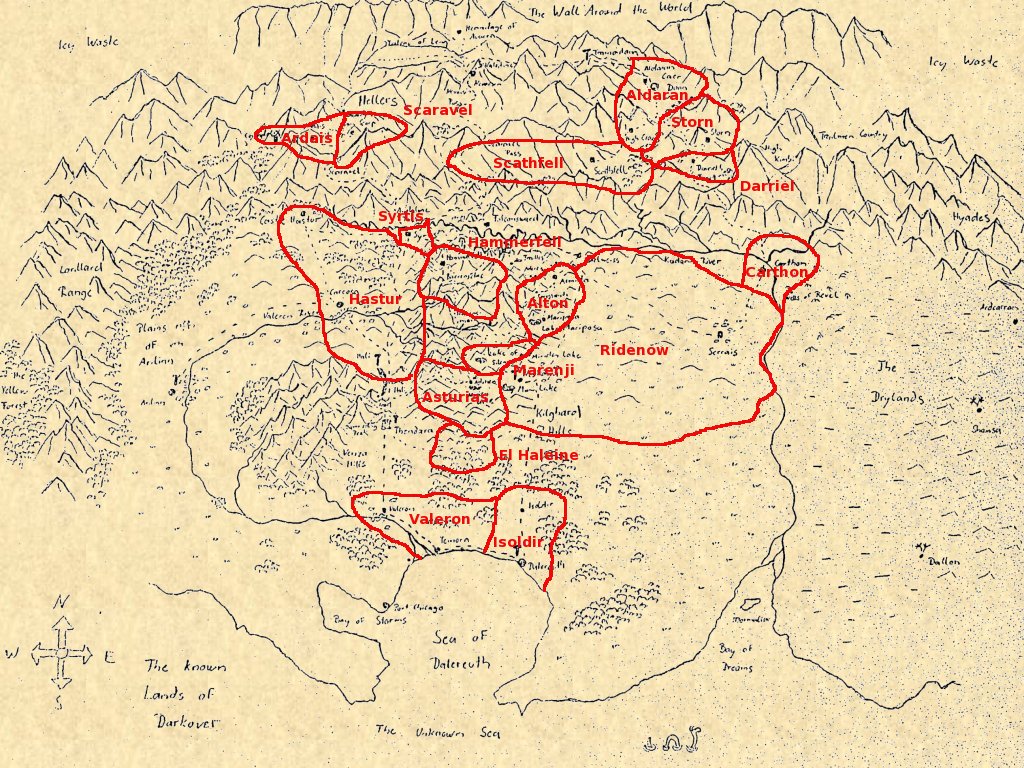
Asturias itself is located in the southern Kilghard Hills. Its strategic situation is as follows: The Hastur lands which dispute the kingship of the di Asturien family are west of Asturias (TTC:341), the Ridenow lands of Serrais, to which also Neskaya belongs (TTC:449) are east (TTC:269) and Hammerfell is north (TTC:201). Since the Ridenow are threatening to attack Asturias in alliance with Hammerfell, Asturias is seeking to use the shire of Marenji (TTC:323) to the north-east and El Haleine to the south (TTC:340) as buffer states to ward against an invasion. Strangely enough, it is made quite clear that El Haleine is in the hands of the McAran and is not identical with Hali (TTC:273).
In the first winter war against Hammerfell (TTC:206ff) king Ardrin of Asturias rides north to hold the bridges across the Valeron between Asturias and Hammerfell (TTC:201) whereas Bard di Asturien rides south into the Plains of Valeron (TTC:213) to capture clingfire being transported from Dalereuth in the south (TTC:200) to Hammerfell. The region around Dalereuth is held by Valeron and Isoldir (TTC:459).
In exile, Bard fights for the kingdom of Scaravel around Sain Scarp in the Hellers (TTC:285). The realm of Ardais (which must be close) is mentioned in TTC:273. Further to the east, Aldaran and Scathfell are independent kingdoms in this age (TTC:340). Finally, the small realm of Syrtis close to the mountains is mentioned in TTC:340.
The mountain kingdoms of Storn and Darriel are conjectured. The Storns are mentioned as a political power in SQ:158 and HM:550 and still hold lands in WD, thus it is plausible that they would hold their own realm. Darriel is based on the existence of Darriel forst (WW:178,183). A Lord of Carthon is mentioned in WW:334, thus presumably Carthon was a realm in its own right at some point. The idea that Altons hold the realm around Armida is likewise inferred from the fact that the Alton family holds lands in the Kilghards earlier (SQ:171) and continue to do so in SS and FT.

In green: The party of Kindra n'ha Mhari and Rohana Ardais frees Jaelle from the Great House of Jalak in Shainsa. The story starts out on the market-place in Shainsa (1) which the renunciates leave in haste after freeing Melora and Jaelle from Jalak (SC:50). However, during the trip through the desert is becomes increasingly clear that Melora goes into labour, and 4 days out of Shainsa Melora's son is born (SC:78) (2). Slowed down, they reach Carthon (3) after a few days (SC:82) and Thendara (4) after alltogether 16 days from leaving Shainsa (SC:81).
In red: Magda Lorne's journey to rescue Peter Haldane from Sain Scarp. Magda starts out from Thendara, but the journey is not described until she is in the mountains. However, it is made clear later that she crossed Andalune pass (1) on the way (TH:311). Afterwards, Magda is roughly travelling northwest into the Hellers (SC:124). In a travel shelter (2) she meets the party of renunciates led by Jaelle n'ha Melora who are travelling to Nevarsin (SC:134). After it is discovered that Magda is not a renunciate, she has to swear the oath and the plan is for Jaelle to bring her to the guild-house in Neskaya, which would be about a 10 day trip from the shelter (SC:152). However, after a fight in which Magda saves Jaelle's life, Jaelle agrees to accompany Magda on her mission to Sain Scarp, and they cross Scaravel pass (3) with some difficulties. Six days after leaving the shelter in which they met (SC:175) they reach Sain Scarp (4). Peter Haldane is ransomed, and since Scaravel pass is closed with heavy snow, they decide to winter in castle Ardais (5) which they reach soon after leaving Sain Scarp (SC:191).
In orange: Jaelle n'ha Melora and Magda Lorne follow Alessandro Li to Armida. After leaving Thendara through Dammerung pass, Magda Lorne faces the choice to go the direct but steep road directly to Armida (TH:706) or to continue past lake Hali and then take the faster road east [west] through the Kilghard Hills to Edelweiss and then to Armida. Magda decides for the direct road (1) and after climbing the first pass at night sees mountain ranges to the east (TH:709) (2). Eventually, both Magda and Jaelle encounter a deceptive cattle trail leading into a maze of canyons (TH:717) where a flood forces them to find shelter (3). Eventually, Magda, Jaelle and Alessandro are found by a rescue party and taken to Armida (4).
In blue: The journey to the hidden city of the sisterhood. The party sets out from Thendara and reaches Ravensmark pass (1) four days later (CS:864). The crossing is difficult, but they reach the high plateau of Barrensclae (2) where they were supposed to meet Rafaelle after six more days (CS:894). From there, they head straight north (CS:897), three days later Magda has an accident however (CS:899) and they reach a village (CS:898) (3). There they are drugged and an attempt is made to rob them, however they manage to get away and cross the Kadarin (4) five days after leaving the village (CS:932). From there, the road rises and they reach the 7000 m elevation of Scaravel pass (5) within five days (CS:935) and Nevarsin (6) a few days later. They leave Nevarsin via the north gate and Nevarsin pass (CS:987) and after three days reach the place where the road to Caer Donn branches off (CS:990) (7). However, they continue along their pass and arrive at the Hermitage of Avarra (8) a day later. After a few days of recovery, they set out again, however are captured and taken to the caves of Acquilara directly in the Wall Around the World (CS:1060)(9). After they manage to free themselves, a guide takes the survivors to the city of the sisterhood in an undisclosed location.

In red: The journey of Dan Barron/Storn. Barron is escorted from Thendara to Armida (1), the seat of the Alton family, which he reaches after five days of travel through the Kilghard Hills (WD:573). From there, Dan Barron is brought to his job assignement in a ranger station (2) in the central high sierra region of the Kilghard Hills. During a Ghost Wind, Storn controls the mind of Dan Barron and leaves for Carthon. His journey (3) takes him six days through diminishing foothills to a plain in the bend of the river Kadarin (WD:632) to Carthon (4) where he meets with Melitta Storn. After trying in vain to recruit mercenaries, they decide to travel to Aldaran (5) and Caer Donn, which they reach six days later (WD:642,648). Here, Desideria decides to help them. An aircraft takes them back to Castle Storn where the Sharra matrix is used to defeat Brynat Scarface.
In blue: The journey of Melitta Storn. After escaping from Castle Storn (1), Melitta finds herself on the north side of the Kadarin (WD:620) struggling through the passes around High Kimbi (WS:623) (2) till she reaches Carthon (3) just in time to free her brother from a difficult situation.
Likewise, the expedition into Trailmen country described in PS to combat an epidemic fever starts at Carthon and leads into the mountains. Since this region is not otherwise described in the novels, it can readily take place there at the fringe of Hellers and Hyades. The only thing that is not compatible with MZB's later accounts is the crossing of Dammerung pass - this name is later given to the pass leading out of Thendara into the Venza Hills (TH:705).

In green: The mapping expedition of Rafael McAran after the crash landing on Darkover. DL does not reveal just where he crash site is, but it is made clear in HM:692 that it is in the lower peaks of the Kilghards and that the settlement of New Skye is the later Neskaya (1). Rafael McAran observed a mountain peak due west [east] of the crash site. But how could he know? At the time of the crash, the season of the year was not established. So the sun could not be used to determine 'due east', and neither did any of the survivors know if magnetic north has any meaning on Darkover. None of the survivors got a look of the planet during approach. Thus, they might well have gone north-west instead. After about 20 miles and 18.000 feet (about 5400 m) elevation gain (DL:12) the peak (2) is reached, and from there Rafael McAran can see all the way to the Wall Around the World. Which is the same view seen by Dan Barron from the ranger station in the high Kilghards described in WD:592.
In red: The expedition of Jason Allison and Regis Hastur into Trailmen country. The expedition starts at Carthon (1) and leads into the foothills of the Hellers (PS:33) across the Kadarin (PS:45) (2). A dangerous watercourse is crossed (3) before the 22.000 ft (about 6600 m) elevation of the pass (PS:65f) (4) are crossed and a forest-covered valley in which the trailmen reside (5) is reached (PS:83).
In blue: The crossing of the Kilghard Hills by Larry Monteray and Kennard Alton. Larry is invited to spend time at Armida (1) from where they encounter a forest fire close to the village Adereis (SD:86) (2). Larry is abducted by Cyrillon des Trailles and brought into his castle (3) from where Kennard frees him. They flee for three days (SD:139) through forest hills till they reach Trailmen country (4) and are captured. After they can talk the Trailmen into letting them go, they take another day to reach the edge of the forest (SD:156) and then six days alltogether to climb up to a pass (SD:158ff) (5). After escaping the banshee, they see inhabited lands again. Descending, they encounter a chieri and are brought back to Thendara.
Some travel times under these conditions are given. We find 11 days from Edelweiss to Aldaran (HH:301), seven days from Aldaran to Alton lands (HH:362) (the difference being that the longer number is into the mountains, the shorter out of the mountains), six days from Carthon to Aldaran (WD:642,648), one day from Neskaya to Edelweiss (HH:242), 16 days from Sain Scarp to Neskaya (from the travel shelter, Jaelle assumes a 10 day trip to Neskaya, but later they take six days to Sain Scarp, so the total distance must be 16) (SC:152,175), 13 days from Thendara to Sain Scarp (SC:121,175), 5 days from Shainsa to Carthon (SC:68), 16 days from Shainsa to Thendara (SC:81), 11 days from Aldaran to Hali (HM:617,621,624), 7 days from Hali to Serrais (albeit indirectly) (HM:651), 4 days from Thendara to Ravensmark (CS:864), seven days from Nevarsin to Syrtis (SQ:57), three from Syrtis to Hali (SQ:57), not more than two days from Armida to Serrais and to Thendara (FT:208), 10 days from Armida to Arilinn (FT:355) and we learn that Hali is an hour north of Thendara (FT:492 - but this must be a bit more, as a pass has to be crossed. On a fast horse, it could be anything up to 40 km though). Roughly these numbers match up. The few examples of vastly different speeds have been discussed above. All known numbers are given in black below.
Other distances can be calculated. For example, going from Serrais to Thendara would involve going from Serrais to Armida (2 days) and to cross the Kilghards towards Thendara (3 days), but a longer journey needs always a bit more rest for the horses, so the distance is given with 6 days below. Likewise, from Nevarsin to Carthon one would go first to Armida (1 day), then to Serrais (2 days) and then to Carthon (1 day), so the distance is given as 5 days. All calculated distances are shown in blue in the table below.
The largest uncertainty is associated with trips to the south to Dalereuth and Temora - here we have no reliable number, and the travel times given here are mere guesses, in principle the south could be much farther away.
| Aldaran | Ardais | Arilinn | Armida | Carthon | Dalereuth | Hali | Neskaya | Nevarsin | Serrais | Shainsa | Temora | Thendara | ||
| Aldaran | --- | 11 | 6 | 11 | 10 | |||||||||
| Ardais | --- | 16 | 13 | |||||||||||
| Arilinn | --- | 10 | ||||||||||||
| Armida | --- | 2 | 3 | |||||||||||
| Carthon | --- | 5 | 10 | |||||||||||
| Dalereuth | --- | |||||||||||||
| Hali | --- | 10 | 1/2 | |||||||||||
| Neskaya | --- | |||||||||||||
| Nevarsin | --- | |||||||||||||
| Serrais | --- | |||||||||||||
| Shainsa | --- | 16 | ||||||||||||
| Temora | --- |
Related links: